Monday, May 26, 2008

Monday, May 26, 2008

Canyon Gap to Willow Road. 9 miles, 563 miles total.


Sunday, May 25, 2008

Cottonwood Bridge Campground to Canyon Gap. 17 miles, 552 miles total.


Saturday, May 24, 2008

Near Highway 138 to Cottonwood Bridge Campground. 18 miles, 535 miles total.


Friday, May 23, 2008

Green Valley Ranger Station to Highway 138. 20 miles, 517 miles total.

The colors of the sunsets and the flowers have been unbelievable!


Right before breakfast at Casa de Luna, Jim, a fireman with LA County Fire Department was dropping off a hiker, and he offered to take me back to Red Carpet Cache. This was close to where I needed to go, so I took the ride.

Just as I was getting out of the truck, it started to rain hard, so I made a mad dash to the cache and set up my tent for shelter. It rained for about an hour or so, and I was glad to have my tent for cover. Once the rain let up, it took 2 more rides to get back to the road that lead up to Burnt Peak Road, the location I left the trail last.

It continued to rain most of the day, and it was cold, but not too bad. Finally, the trail dropped below the clouds, and I was able to find a dry place to put up my tent. All in all, it was a good day on the trail.

Thursday, May 22, 2008

Thursday, May 22, 2008

Green Valley, back at Casa de Luna. Zero day today! (I should have taken a zero day yesterday, rather than do the 20 mile hike!)

Today was very relaxing, and I really needed it. Started out again with Hot Cakes. Took a nice nap in the afternoon. I may try to go back to Burnt Peak Road late this afternoon, or first thing in the morning. Several hikers left today, and some new ones arrived. I'm still ahead of the "herd", but not by much. This place is like nothing else I've ever experienced. I feel right at home here, and everyone is having a great time. Some hikers stay longer than others, and that's OK. Joe and Terrie seem to have a fun time being host to hikers.

This is Joe and Gadget discussing the finer details of Disc Golf.

Wednesday, May 21, 2008

Green Valley (Casa De Luna) to Burnt Peak Road water cache. 20 miles, 499 miles total.

This is me in front of the large white sheet that everyone writes their trail name on.

Joe and Terrie Anderson are "one of a kind!" They're really not wierdos!


After a great night's sleep, everyone was treated to hot cakes and syrup made by Terrie Anderson! What a great breakfast!

Some other hikers were going back to the ranger station, so I took an early ride and hiked 20 miles to Burnt Peak Road. Dave was there stocking the water cache. It was very cold and windy ... too windy to set up my tent, and I was really feeling like I should have taken a zero day at the Andersons. Dave said he'd take me back, and even though I'll have a difficult time getting back up that bumpy dirt road, I decided that I'd go back to the Casa De Luna and take the zero day that I should have taken in the first place.

It was about 8:00 p.m. when we got back to Green Valley, and Joe was in the middle of "Story Time", another great past time at the Anderson House!

I ended up sleeping on the couch. What a treat!

Tuesday, May 20, 2008

Bear Springs to Green Valley Ranger Station. 15 miles, 479 miles total.

You never know what you might find on the trail.


Welcome to Casa De Luna! Joe and Terrie Anderson are awesome! What an experience to stay here! First, everyone is instructed to grab a Hawaiian shirt from a very large pile of shirts. Next, get your photo taken and sign your trail name to a large white sheet hanging by the garage door.

In case you don't know yet, my trail name is "So Far".

At night, Terrie makes the greatest Taco Salad that I've ever tasted. There's several coolers with soda and cold beer by the chairs in the driveway, and out back, there is this wonderful forest where you can set up your tent.

Disc Golf is one of the approved past times here, and I got to play a round of 9 holes with Joe and six other guests. It was a great time.

Monday, May 19, 2008

Agua Dulce to Bear Springs, 9 miles, 464 miles total.

This is the Saufley's "Hiker Heaven".


I had a great time at the Saufley's house in Agua Dulce. Today, I rode the train into Burbank and met my old boss, Ross. We had a great lunch, made a quick stop at the Post Office and another re-supply stop at Von's. Ross drove me back out to Agua Dulce, and even thought I tried to convince him to join me on the trail for awhile, he declined.

I packed up my new supply of food, fuel and supplies, and at about 5:00 pm, decided it would be a good time to leave. Hiking in the evening and after dark was a great way to beat the hot weather, and there was a full moon out. About 9 or 10 hikers all set out during the early evening.

At about 10:30 p.m., I was getting very tired, and I found a great place to put up my tent. It was my plan to sleep a few hours, then head back on the trail. I wanted to get to Green Valley before the hot part of the day.

Monday, May 19, 2008

Sunday, May 18, 2008

Robin's Nest RV Park to Agua Dulce (Saufley's Place), 10 miles, 455 miles total.


I got a nice early start at 6:00 a.m. It was a good thing, too, because it quickly became very hot.

The trail headed down to Highway 14, then went under the highway through a long tunnel. On the other side was Vasquez Rocks, a great campground where I used to camp when I was about 8 years old with my family. It brought back some wonderful memories, and the rocks all look just like they did 40 years ago, except for all the houses that have built up around the park.

Once I made it to the Saufley's place, it was amazing! This is such a relaxing place to be. There are about 20 hikes here right now, but this place can easily accomidate about 50 to 60 hikes. Donna is wonderful, and she makes everyone seem so welcome. She washes your clothes for you, and even organized a work crew to erect three more large tents with cots. There was a nice campfire, and they even have 8 bikes that you can use to ride about 10 blocks to the local market. I can see how hikers could easily take a week off and stay here to relax!

Saturday, May 17, 2008

North Fork Ranger Station to Robin's Nest RV Park. 8 miles, 445 miles total.


It was a very relaxing morning, and it got very hot during the middle of the day. The ranger station had good water, so I decided to take a rest day to let my foot heal. It was feeling like a blister trying to develop, and I didn't want that to happen. I thought the rest day would do me good.

Several other hikers came to the ranger station during the day. Most stayed a little while, then headed on. Joker showed up around noon, and I found out the Seven and Julian were ahead of us. They spent an extra day in Wrightwood.

By 3:00 p.m., there were about six hikers there, relaxing and staying out of the heat. Most were planning to make a run to the Robin's Nest RV Park, so I decided to pack up my gear and go with them. We all loaded up with water and started on our way. It wasn't a difficult hike, and I was sure glad that I went along.

Once at the RV Park, we got a group rate ($4 each) to camp, and there was a large Mexican Celebration going on. I was able to enjoy some free food (very good food, too!), and we all took a quick dip in the swimming pool. It was very refreshing! The one down side was the Mexican Band (with about 15 members in all) played music until at least 2:00 a.m., so it was difficult to sleep!

Friday, May 16, 2008`

Jeep Road to Morth Fork Ranger Station. 21 miles, 437 miles total.


I started the day at 7:30 a.m. It was a warmer day, again. There are 1,000s of flies, and they get right in your face and they won't leave you alone!

I arrived at the Ranger Station just before 10:00 p.m. I wanted to stop sooner because my right foot was hurting a little, but there just was no place to set up my tent. At the Ranger Station, there was a restroom and an nice sandy spot just for a tent! I slept really well there.

Thursday, May 15, 2008

Three Points Rest Area to a Jeep Road, 10 miles, 416 miles total.


I'm not sure this photo of the sunset really matches what it looked like. There were so many layers to the mountains, and the smog from LA added to the bright orange color. My sunglasses are polorized, so the colors are even more brilliant than without them.

After spending the morning in Glendale, I was able to hitch a ride back to Three Points with Sam. He was on his way to a men's retreat just a few miles from where I was picked up yesterday. We had a great conversation on our way up the mountains.

Wednesday, May 14, 2008

Wednesday, May 14, 2008

Cooper Canyon Camp to Three Points. 10 miles, 406 miles total.

I finally made it a to a place with a decent computer, and I was able to upload photos all the way back to April 23, so make sure you go back and see some of my photos. I tired to add additional comments to go with the photos, and I'll do some more updating later. There is still a lot of text that I need to add.

This is shot of the cabin at Glenwood Camp.


This is a photo of Jason and Leah. They gave me a ride to town today! Thanks.


I haven't talked about this in a while, so now seems like a good time to bring it up.

Everyone that is following this blog is invited to come to the town of Sister, Oregon for my "end of the Journey" celebration during the month of December, 2008 and early January, 2009. It's my plan to rent a large Mountain Retreat there and practice running a Bed and Breakfast. If you come, there won't be any charge for lodging, and I hope that I can accomidate everyone. I'll be running a shuttle to the Redmond Airport (near Bend, Oregon), and I'll help everyone if they want to go skiing at Mt. Bachelor or HooDoo Ski Resort. Both of these are within an hour (or so) from Sisters. Another way to get there is to fly to Portland and rent a car to drive to Sisters. In good driving conditions, this is about 3 or 4 hours of driving from PDX.

So, if you are thinking that this is something you want to do, here's what you need to do: Send me an e-mail to stephen_fosdick@yahoo.com and let me know what kind of room(s) you will need (Queen or Twins), and the aproximate dates you think you will be there, if you are driving or if you will need to be picked up at the Redmond Airport. Right now, I'm planning on having rooms available from December 20 thru January 3, but I can expand the dates (earlier in December) if so many people come that there aren't enough rooms. If I expand the dates, it would be from about the sixth of December thru January 3.

Alaska Airlines has flights to Redmond from Los Angeles, Seattle and Portland.

When you are ready to check out travel arrangements, please visit http://www.ytbtravel.com/100biketours.

I hope to see everyone in Sisters in December!

Tuesday, May 13, 2008

Little Jimmy Campground to Cooper Canyon Camp. 12 miles, 396 miles total.


It was very windy today ... sometimes the wind is so strong that it is difficult to breathe and I feel like the wind might blow me off the trail. I could hear the wind in the night, blowing the tops of the trees, but my tent didn't blow around too bad.

The trail seems to stay on the crestline most of the time ... I guess that's why the call it the Pacific CREST Trail and not the Pacific VALLEY Trail or the Pacific COAST Trail! I think I'm ready to have the trail go to a lower elevation, but once I reach the Serra Mountains, I'll really be up in the sky!

I lost the trail for most of the afternoon. I really didn't know for sure where I was. The trail I was following was just a scant trail, but I could tell that others had hiked it recently, so I pressed on, climbing every little peak in sight, it seemed. Eventually, I knew that I had to cross the Burkhart Trail, and that I could take this trail back to the PCT. Sure enough, that's what I did.

There was a sign saying that part of the PCT was closed to protect the breeding gournds for the Yellow Legged Frogs, so I guess it was a good thing that I was on a different trail anyway.

I camped at a very nice location near a creek, and had a nice big dinner. I have to eat more food to help make my pack lighter!

Monday, May 12, 2008

Inspiration Point to Little Jimmy Campground. 15 miles, 384 miles total.

After a nice breakfast of waffles with Boysenberry Syrup and coffee, Marion drove me and Wasa to the trail ... about 5 miles up Highway 2 from Wrightwood. As we arrived, three other hikers were just getting to this junction, so she gave them a ride back to town! Wrightwood was very hiker-friendly!


This is a photo of me at the top of Mt. Baden-Powell, at about 9,300 feet.


There were a lot of switchbacks climbing up this mountain, and there was a lot of snow on the trail. At times it was very difficult to follow the trail, and from the footprints in the snow, I wasn't the only one have a hard time. I'm glad it wasn't hot!


I finally made it to Little Jimmy Campground, and there was a nice spring with water just before the campground. Water seems to be easier to find right now, and I was able to re-supply in Wrightwood with more than enough food to make it all the way to Auga Dulce ... the down side is my pack is a little heavy, but not too bad.

Sunday, May 11, 2008

Sunday, May 11, 2008 - Mother's Day

Guffy Campground to Highway 2 (Wrightwood). 4 miles, 269 miles total.

This is a photo looking back at Mt. Baldy.


Highway 2 has a large rock slide that blocks the road, but it's not too hard to hitch a ride back to Wrightwood from the spot where the trail crosses the road.

At the hardware store in Wrightwood, I meet a very nice local resident that invited me to stay at her mountain home. It wasn't a large place, but it sure was nice! She allowed me to do a load a laundry, take a nice warm shower, and I used her sewing room in the back of the garage as my bedroom. She even cooked Salmon for dinner. It was great!

Saturday, May 10, 2008

Just past I-15 to Guffy Campground. 21 miles, 365 miles total.


Today, I had a big climb up to 8,250 ft. It was cooler at that elevation and it should be cold at night. The two tall peaks with snow on them are Mt. Baldy and Mt. Dawson. Several other campers were at Guffy Campground.

Friday, May 9, 2008

Silver Lake Group Camp to just past I-15. 14 miles, 344 miles total.

This is Mendo Rider and his horse, Pemo. They are riding from Campo to Ashland, Oregon. He gave me a ride into the town of Julian several days ago. It was nice to see them again here at Silverwood Lake.


This morning, Mendo made wonderful pancakes for breakfast, and invited me to join him and wife. I couldn't turn them down, you know! That would be rude!

After about 5 hours of hiking, I came to the PCT McDonald's Restaurant. It's about 2 long blocks off the trail just before the trail crosses under Interstate 15 at Cajon Pass.


I hiked about 2 miles past the freeway. I couldn't hear the freeway noise, but there were three sets of railroad tracks right next to the freeway, and you could hear trains all night long going in both directions. I found a nice place to camp under some trees, and that helped to muffle a little of the noise, but I still didn't sleep too well.

Thursday, May 8, 2008

Deep Creek Hot Springs to Group Camps (Silverwood Lake). 24 miles, 330 miles total.


Wednesday, May 7, 2008

Holcomb Creek to Deep Creek Hot Springs. 22 miles, 306 miles total.


It was an easy day, and I got an early start today. I stopped a few times during the day. Deep Creek was amazing, although I would have preferred to be hiking closer to the creek. Most of the time in this canyon, the trail was about 100 yards up the ridge, with the creek down a steep cliff below.

This is a brige that crosses the creek.


Finally, after about 10 more miles, I came to the Deep Creek Hot Springs, and this was a great way to end the day. I camped really close to the man-made pools and soaked 4 times in the 104 degree hot pools. It would have been nice to take another zero day here, but I feel the need to continue to make progress.

Tuesday, May 6, 2008

Van Duzen Road (Big Bear Lake) to Holcomb Creek. 10 miles, 284 miles total.

This is Gracen from the Big Bear Lake Mountain Resort Hostel (909) 866-8900. He's a wonderful host, and will come and pick you up at the trailhead if you call him.


I was able to hitch a ride with a local resident named John back to Van Duzer Road to get back on the trail. I got to the trail at about noon, so I didn't get as early a start as I would have liked. Even though I was at the Big Bear Lake Resort Hostel for 3 nights, it realy was only one zero day hiking-wise.

Today's hike took me through a large burn ... about 9 miles or so. There was a detour by the forest service that would have been 17 miles on old dirt roads. I'm glad I didn't take the detour. The sign indicated that it was ok to stay on the trail, you just can't camp in this section. As soon as I got to the other side of the detour, I camped at the first decent place I could find. I thought the burned area would last for ever! I believe this burn was from last year.

Monday, May 5, 2008

Highway 38, Big Bear, to Van Duzen, Big Bear. 20 miles, 274 miles total.

Slack-packed today. Peter from Equada Outfitters (909) 866-6186 gave us a ride in his cool Swiss Army Vehicle to the trailhead.


I hiked with Joker and Julian Southbound, making up the section that we missed by getting off the trail at Highway 38 rather than going all the way to highway 18 like most of the PCT hikers. We passed at least 40 hikers going North, and it seemed like we had to stop and talk to all of them!

"Eric the Black" came and picked us up again at the same place he did on Sunday afternoon and took us back to the Hostel at Big Bear Lake. He's the author of the Pacific Crest Trail Atlas ... the best set of maps of the trail that I've seen yet!(http://www.pctatlas.com/). Thanks, Eric!

It was a great day of hiking, especially without our heavy packs!

Sunday, May 4, 2008

Zero Day at Big Bear Lake Hostel.

This is a great place to stay in Big Bear. There are about 20 other PCT hikers staying here. The showers are hot, there a washing maching and dryer for clothes, and everyone is sharing food. There's a full kitchen for cooking, and the grocery store is not too far away. It will be nice to take a few zero days here to rest.

Sunday, May 4, 2008

Saturday, May 3, 2008

East Fork of Mission Creek to Highway 38, near Big Bear City. 21 miles, 250 miles total.


Caught up with Joker and Julian. We decided to walk out to Highway 38 and find a ride to a Hostel at Big Bear Lake. Eric came and picked us up. I'll take a few zero days here and re-supply with food. There are several other hikers staying at the Hostel, so it's going to be a fun time!

I'll be taking a zero day tomorrow to do some wash, catch up on the blog, and go shopping. I'll be needing about 5 days worth of food when I leave here. We are planning on about a 24 mile hike (without packs) tomorrow near Big Bear. Then I'll be back on the trail again.

This is a great Hostel!

Friday, May 2, 2008

Wildlife Conservatory to East Fork of Mission Creek. 10 miles, 229 miles total.

I really enjoyed my stay at the Wildlife Conservatory. This is a "must do" stop as far as I'm concerned.

I was glad that I had my new sandals, as I used them to cross Whitewater Creek. It was cold and swift, about 6' wide or so. I also got some more water here.


Later in the day, I made it to the East Fork of Mission Creek (at mile 226) at noon. I took a little soak in the cool creek. I didn't need more water yet, and as it turned out, the trail follows this creek a long ways.

It was an extremely good day for me ... maybe my best day yet on the trail. The slope climbed slightly, but there were plenty of trees along the creek to keep it cool. The flowers were everywhere, and I didn't see another hiker until very late in the day. By the time I stopped for the day, I had crossed the creek 18 times.

I camped next to the creek, and sound of the bubbling water made it very easy to fall asleep. I'm starting to get low of food, so my next re-supply stop will be in Big Bear City.

I'm having an issue with my pack, as my right shoulder blade hurts once in a while. I'm not sure if it is the pack or if it might be due to using the treking poles. I plan to get rid of some of the items in my pack at Big Bear City, so that should help some. I did get rid of a few things at Whitewater Creek, and with my food supply low, my pack is actually lighter than it was a few days ago.

In several places along the trail, the entire hillside was covered in dark purple flowers. I'm not sure the photo will do it justice. (I wish that I could up-load some of my photos here, but this computer does not have a USB jack.)

Thursday, May 1, 2008

Power Lines near I-10 to Old Trout Farm (Wildlife Conservatory). 11 miles, 219 miles total.


I got up early and made a dash for the freeway undercrossing. It wasn't too difficult to find the trail markers once the sun was up. I was about 100 yards off the trail where I made my camp for the night.

After crossing under I-10, I was going to try to go to Cabazon or Banning. I knew that I had not made any postings to this blog, and people were starting to get worried about where I might be. Most of the time, my cell phone doesn't work, either, and I try to keep it turned off during the day to save on the battery.

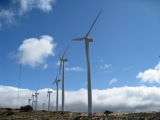
Not too long later, I met a young couple from Belgium. They call themselves the Belgium Waffles. I stopped to eat breakfast at the Mesa Wind Farm Gate, and a little later went to the wind farm office to get some water. The workers there were very nice, and they had a large stash of bottled water that they make available for hikers. It was nice to get such a warm welcome from them.

These are the wind mills at Mesa Wind Farm.


My next stop was the old trout farm, now called the Wildlife Conservatory, at Whitewater Creek. This was a great place to camp. An older couple there gave me some of their strawberry shortcake, and the place had trees and a nice bathroom. The only thing that would have made this even better than it already was would be showers!